I think dev should do that. Unite all maps and create a wold map. Like skyrim,gta,lotr etc.
Edit: I didnt mean a map for playing. I mean a map for posters, Wallpapers, etc.
For the map to even be playable it would need to be bigger rhen any Map we currently have.
I can already imagine the lag
It is not for playing. It is for wallpaper,puzzle, poster etc
1 Like
The problem is that such map would have to be awfully large to have any reasonable level on detail for areas like Europe. And I don’t think a lot of players want to spend hours conquering Siberia or other sparsely populated parts of the map.
Instead, I think maps more focused on a continental level would be much better, maybe walling off parts of the map that wouldn’t be relevant in a realistic scenario.
Here are some suggestions that I think make some historical sense :
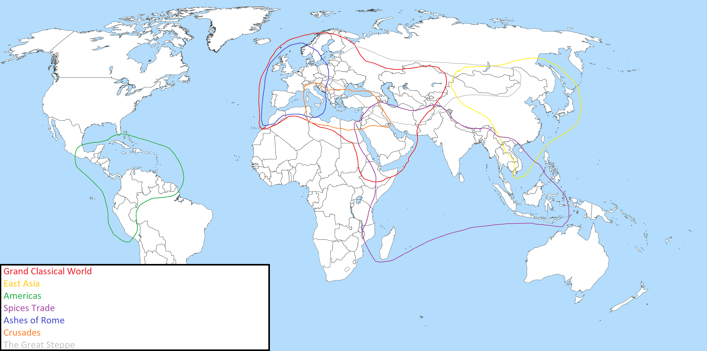
The Grand Classical World Map : a gargantuan map stretching from Iberia to Transoxania and from Scandinavia from Ethiopia, covering the entirety of Europe, the Middle East, Central Asia and North Africa. This is as close from a full world map that I think is reasonable.
East Asia map : China, and its historic sphere of influence. Who will be the emperor ? Will the ruling dynasty keep its throne, or will some usurpers raise from within ? Will China be conquered by a rebellious former tributary, or by a new threat from beyond the Great Wall ?
Americas map : mainland America from Mexico to Peru, while also covering the Carribeans where new threats might arise
Spices trade map : a map covering the entire Indian Ocean. Controlling this lucrative market will require crushing every self-proclaimed Sultan, Shah or Rajah.
Ashes of Rome : a map covering Western Europe and extending south of the Mediterranean. Rome may have fallen, the strongest kingdom will become the new empire of the West
Crusades : from Italy to Mesopotamia, centered on the strategic locations of Constantinople and Jerusalem
The Great Steppe : what is this giant sea of grass stretching from Poland to Mongolia, except a natural invitation to be ruled by the strongest Khan ruling the largest horde ?
You should probably make that clear in the title and/or explain it in the first post – otherwise people are going to misinterpret it. The only explanation in your first post was “Like skyrim,gta,lotr etc.”, which doesn’t help much, especially for people who don’t play Skyrim or GTA. (And as an aside, I think most copies of LOTR actually contain four separate maps rather than one – and Middle Earth is very deliberately not the whole world anyway.)
But I do like the idea of making this kind of world map image, and coincidentally had been wondering recently whether it would be possible. You could take full map screenshots with CaptureAge and piece them together. However, as I see it, there are three difficulties with that:
- The maps have different scales. For instance, the map for the Legend of Prithviraj depicts the whole of India, but it’s smaller than the map for York, which depicts the British Isles. Meanwhile, maps from William Wallace and Edward Longshanks depict parts of the British Isles on a larger scale.
- There are overlaps between maps that don’t agree. Different depictions of the same locations appear in different scenarios, e.g. Constantinople, Acre, Kyoto, the English Channel, etc.
- There would be gaps, since some places don’t feature in any scenario. I suppose some of these could be filled in by using the real world maps, but those are usually at a smaller scale, so that takes you back to point 1.
I think the combination of these three points would make the end result a bit of a mess. That said, I’d still be interested to see what it would look like!
As added complications :
- Some maps do not closely follow real geography. It’s actually quite uncommon until the latest campaigns to have a realistic geography, it’s often highly distorted for gameplay reasons
- Some also do not have the same orientation. Sometimes the north is to the upper corner, sometimes the upper left edge and sometimes the upper right edge
1 Like
Good points, I hadn’t picked up on the orientation thing. The scouts’ reports are always written as if North is up, I think.
If you look at the west European building graphics, you’ll notice that west must be to the top-left, since that’s the way the west front of the Monastery is pointing… Until you compare it with the Britons’ Wonder and realise that its west front is pointing in the opposite direction!
1 Like
The north is always in that wide general direction but it changes from map to map. I’d say maps are within +/- 45 degrees from the right angle.
There’s also the frankish wonder with yet another direction, and then the central european monastery. So, using churches the east can be at any of the 4 map edges 