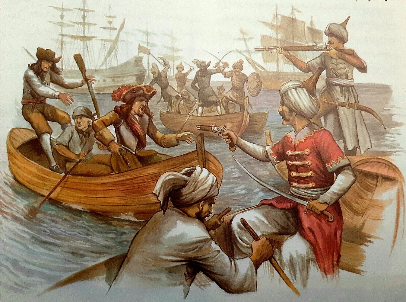
The guy who claims himself as the creator of the first picture said on Reddit, that he added Greenland himself.
On Persia I would also like more than one map. But considering how big the Asian maps are it is not impossible that it is only one. Also the name Persia is small enough to be hidden in the space that we don’t see yet. Of course this area could be added later but it would surprise me if they added all the areas between Asia and Europe except this southern part.
On the Eurasian steppe and Siberia border: did you consider this shiny line in the middle of yamal and central Asia as indicator? I did so in the beginning but this line is on every new map. Of course there is the possibility that there really is no real border on the maps.
And one more question:
I compared the Asian maps and central Asia. Is there a real life item (lake of River) that made you connect Mongolia to central Asia?
In both the central Asia and the Asian maps it looks like Himalaya is going all the way up without Mongolia touching central Asia.
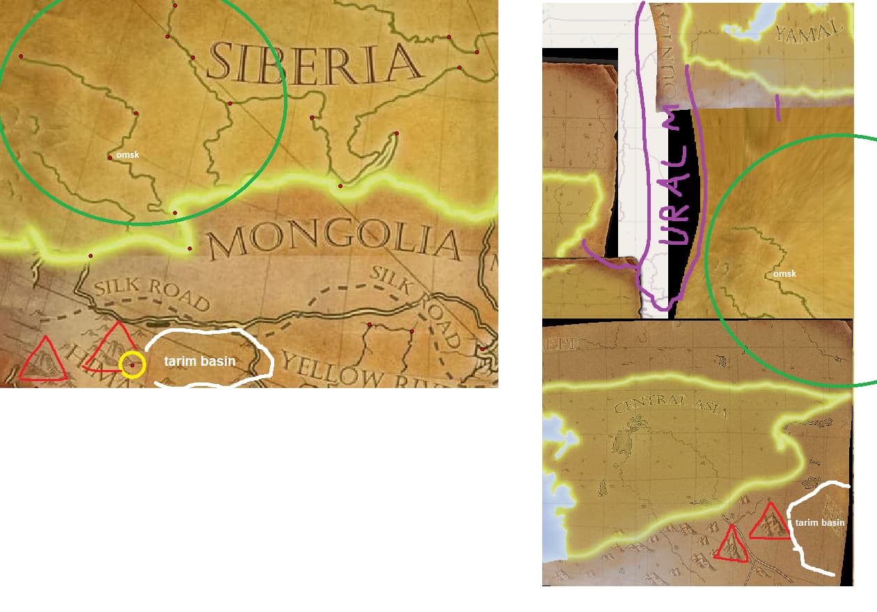
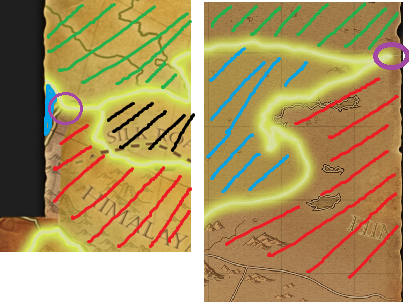
fortunately for us, the river at omsk is distinctive enough to recognize. The spots in the green circle are all connected to the flow of siberian rivers.
circled in yellow i estimated a point; its roughtly the western most edge of the tarim basin… its definitely not perfect, but its onlyone, to atleast somehow fixate this area near the himalayas on a real map. After i applied it on the program, the two big mountains (marked red) matched perfectly on the old (himalaya) and the new map (central asia); i dont know what specific mountains they are supposed to be, but i think its a good sign, that they match.
so there are 2 points left between the green circle and the tarim basin/2 mountains; the eastern point is a part of the modern chinese mongolian border, that fits very well;
the western point is roughly defined by a river in kazakhstan (but it gets covered by the central asia map later on anyway.
Edit: its possible, that mongolia will apear smaller in future maps… but even then, i think central asia will bodyblock himalaya from connecting to eurasian steppes/siberia
no, i didnt know what border it was supposed to be ^^’ but after your message i also think its not a real border and just some graphics aswell.
I guess the developers let some open room to reorganize the area for eventual future updates, also a reason why there are no clear borders between siberia, eurasian steppes, mongolia and himalaya shown on 2022/23 maps. maybe siberia gets split even more, like what they did with yamal…
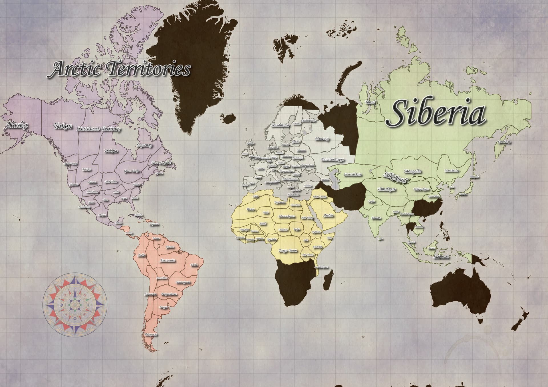
This is a problem I have with the Asian maps. They cover way too much territory. Ditto for South American maps. Makes it really hard to add more minor civs to these regions, and also makes the current ones way too umbrella-y.
Wow realy good work finding all the rivers and landmarks. took me a while to find them im GoogleMaps. Now it looks like Mongolia, siberia and Himalaya went more into the west in the asian dynasties map than they do on the new maps. The reason why I think mongolia is not touching central asia is the borders of the maps seen below. (Green is Eurasian Steppe/Siberia, Blue is central asia, black is mongolia, red is himalaya) In the purple circle is the point where I think himalaya, cental asia and siberia are meeting.
But I think you did a very good job combining all the maps. Honestly great work!
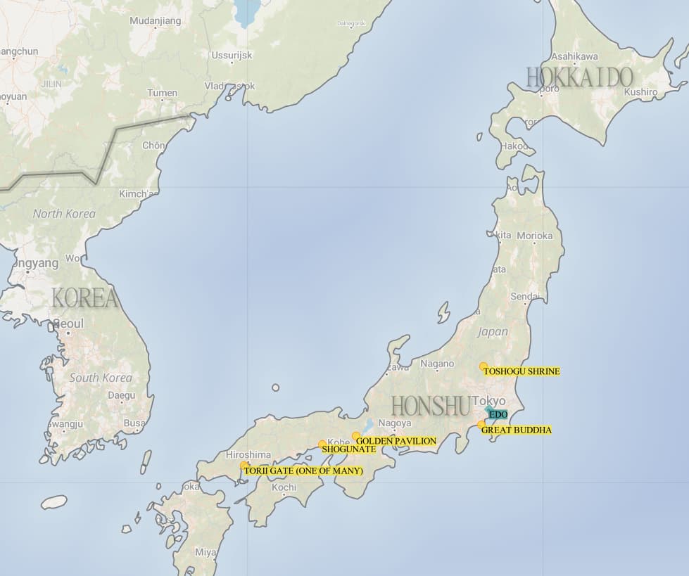
I’m counting on a total rework of Asian maps all the time. I can’t accept the fact that all of China and India are only 2-3 maps. I think that most of the areas on the map of Asia could be divided into two. It would also be nice to see maps with characteristic places, e.g. a Japanese map with the Fuji volcano (and numerous cherry blossom trees ).
In the case of the Middle East, I think he has the luxury of not being in the game yet. This allows developers to give it their own unique feel and features that don’t need to be shared with other Asia maps - so they can have unique Minor Civilizations, separate Trading Post features, their own treasures and guardians, and so on.
Yes, I think they will eventually put in and divide more Asian maps in the next Asian dlcs… I mean, remember that we still lack one DLC from the Middle East (Persians and Omanis), one dlc from Central Asia (Tatars and Uzbeks) and two DLCs from Southeast (Burmese and Siamese) and East Asia (Koreans and Vietnamese)…
(high resolution: Imgur: The magic of the Internet)
also updated with wales and the previously missing maps (silk road, plymouth, central plain…)
after revisiting my old map, i think you (@PersiasRerising ) were correct about the area between mongolia, central asia, hymalayas so i corrected it aswell
if you guys have any wishes, let me know and of course tell me if you find mistakes^^
special thanks to the Age of Empires Series Wiki | Fandom since i mostly used their sites for further information. check out the trivia/history/comments, its really neat ^^
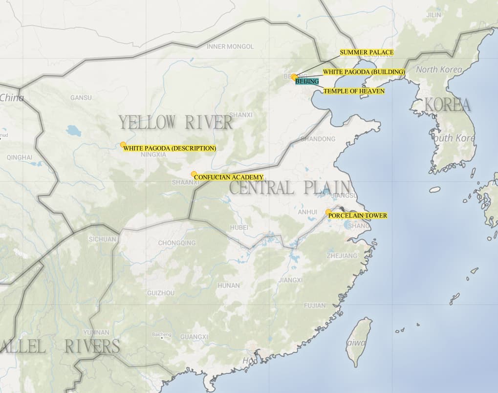
In China, when most people think of Confucius academy or Confucius temples, they may think of Qufu, Shandong Province, where Confucius was born, but I think it is very reasonable to judge from the shape of the building, because in theory, all cities in China have Confucius temples.
The black parts in the Europe may be the following.
Greenland:
A V-shaped peninsula map, players are located on the sides of the coast. The water is rich in fish and whales, and the coast is rich in prey, trees and mines, but inland is an open snowfield and ice sheet without any resources, trade points and shelters. You can choose to control the coast through the navy, or attack directly through the snow inland at the shortest distance.
Iceland:
A map of an island the size of Borneo, but in the center or south of the island there is an unclimbable snow mountain like the mountain in Hokkaido.
Sápmi (or Lapland):
Similar to Scandinavia, but only has the sea on one side and the sea is larger. There is no royal house.
Svalbard:
Similar to Caribbean, rich in whales, but all three lands are smaller, closer to each other and surrounded by sea. There is a chance to find a small piece of land representing Franz Josef Land on the edge of the map. There is no royal house, and there is a water trade route instead of a land trade route.
Novaya Zemlya:
Similar to Panama, a slender land divides the map into two seas on the left and right, but there are no small islands in the sea, and the land is straight from north to south without bending and may be narrower. There is no royal house, and there is a water trade route instead of a land trade route.
Ural Mountains:
Slightly higher mountains throughing the map, with flat plains on the left and right. There are rich mines in the mountains. East of this map is Asia.
Transbaikalia
Posee un gran lago en el centro que puede congelarse en invierno, ruta comercial rodeando el lago, montañas en los bordes,casa de Oldemburgo y tengri por el mapa. Comienzas con un bote de pesca. https://youtu.be/rdNz14g_10Y